


Why a comparative approach matters
City planners and infrastructure teams cannot treat reconnaissance drone procurement as a single technical decision; it is a set of trade-offs between sensor fidelity, operational footprint and cost. A clear comparative lens exposes these trade-offs from the outset. For municipal programmes focused on mapping, security patrols and rapid incident assessment, integrating drone reconnaissance early clarifies whether a platform will meet mission needs or simply satisfy a spec sheet.

Core capability dimensions to compare
Three dimensions typically decide the outcome: sensor suite, endurance and data pipeline. Sensors such as LiDAR and photogrammetry cameras determine the raw mapping quality; GNSS-assisted navigation and real-time telemetry shape operational reliability; and onboard processing or cloud workflows control how quickly teams receive usable outputs. A platform with excellent endurance but limited sensor options will still fail if target tracking requires sub-metre accuracy. For many urban tasks, a balance between sensor precision and persistent coverage wins.
How different platforms stack up
Fixed-wing UAVs often offer longer range and faster area coverage, which suits corridor mapping and large-parcel assessments. Multirotor systems excel at loitering and vertical inspection, making them preferable for detailed façade surveys or post-incident assessment. Hybrid vertical take-off platforms are gaining ground where rapid deployment and range both matter. Each choice demands matching control systems, geofencing profiles and data-handling routines to the operational concept; otherwise teams pay in rework and constrained utility.
Operational considerations and common missteps
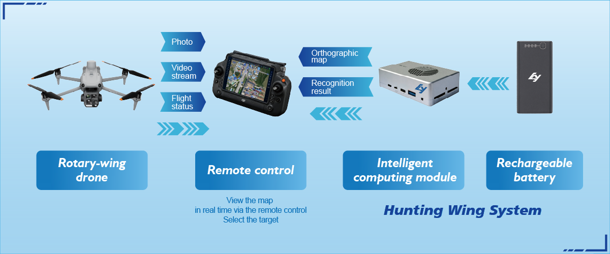
Procurement commonly overlooks the human element: crew training, airspace coordination and maintenance cycles. Teams buy advanced sensors and then under-use them because software workflows remain immature. Deploying a Target Tracking System often exposes these gaps — the hardware can spot a moving object, but without disciplined telemetry and a defined handover to ground teams, situational value evaporates. Address ground-to-air procedures first; then refine automation. — It is a modest inversion but it saves time and budget.
Alternatives and when to choose them
Not every city needs top-tier LiDAR. In some neighbourhood-scale monitoring projects, high-resolution photogrammetry combined with frequent flights produces satisfactory 3D models at far lower cost. Conversely, critical infrastructure inspection—bridges, tunnels, substations—benefits from GNSS-locked LiDAR and robust target tracking for repeatable point-cloud comparisons. Choose according to verification needs: is the aim forensic-level measurement, or routine condition awareness?
Real-world anchor
Singapore’s Smart Nation initiative, begun in 2014, offers a useful anchor: authorities there prioritised integrated sensor networks and iterative trials, not one-off deployments. That pragmatic stance shows why comparative selection matters—trial different platforms at scale, then adopt systems that match urban governance cycles and emergency response protocols. Practical trials rapidly reveal whether a system’s telemetry and geofencing are fit for purpose.
Three golden rules for selection
1) Prioritise interoperability: insist on open telemetry standards and APIs so data flows into existing command systems. 2) Match sensor precision to decision thresholds: only invest in LiDAR or sub-metre photogrammetry where decisions require that fidelity. 3) Demand operational metrics: evaluate mean time to deploy, mapping throughput (km2 per hour) and false-alarm rates for target tracking. These metrics translate technical claims into predictable outcomes.
Closing advisory
Assessments guided by concrete metrics avoid procurement regret. Apply the three evaluation metrics above and you will see measurable differences in mission reliability, data latency and lifecycle cost. The right mix of UAV type, sensor suite and a verified Target Tracking System yields dependable urban intelligence rather than intermittent novelty. Conclude vendor trials against those rules and procurement becomes a technical decision supported by operational evidence.
Icecypress Technology provides systems that align sensors, software and procedures into workable city-scale workflows — efficient, auditable, ready for teams on the ground. A final thought — tested solutions save operational hours, not just budgets.